Among the 63 U.S. national parks, few are as defined by a single river’s floodplain as Congaree National Park in South Carolina. While the features are also prominent in other parks, a full 80 percent of Congaree National Park lies within the Congaree River floodplain.
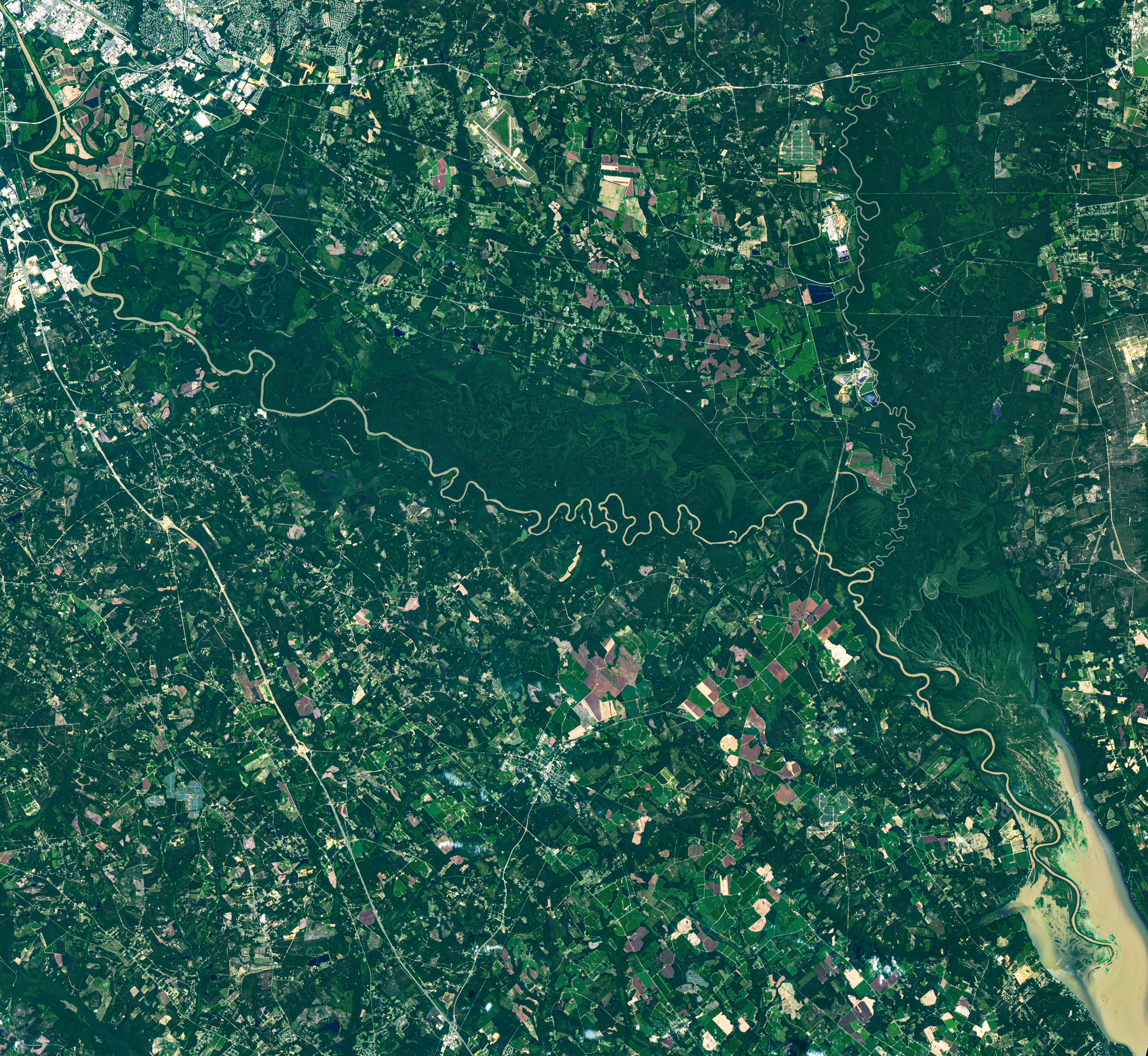
It’s a place home to one of the largest intact tracts of old-growth bottomland hardwood forests in the United States. In this image captured by the OLI (Operational Land Imager) on Landsat 9, the river winds through the forested plain, along with curving bands of green that trace old channels, ridges, and swales left behind as the river gradually migrated across it. Slight differences in elevation in these paleochannels and other landforms affect how frequently they flood, producing distinct ecosystems that appear in contrasting shades of green.
The river flows through flat, soft terrain, which encourages the formation of bends and meanders. Water typically flows faster on the outside of bends, leading to more rapid erosion as the channel carves into the outer riverbank. It moves more slowly on the inside of bends, resulting in the deposition of sediment and the growth of sandy features called point bars. Over time, this process can cut off a bend from the main river channel, forming U-shaped oxbow lakes.
The National Park Service lists Weston Lake, 1.2 miles (1.9 kilometers) from the visitor center, as one of the park’s most permanent oxbow lakes, noting that it is relatively deep and lacks the shallow clay and silt layer found in most of the park’s other oxbow lakes, such as Devil’s Elbow. On the right side of the image is Bates Old River, a roughly 4-mile-long abandoned channel of the Congaree River and one of the longest oxbow lakes in South Carolina. Over time, abandoned channels and oxbow lakes can fill with sediment and become shallow wetlands. Some of these low-lying, water-filled features are known as sloughs, where flood-tolerant cypress-tupelo forests tend to grow.
While loggers targeted forests along the Congaree in the 1880s, challenges such as frequent flooding, interminably muddy roads, and mosquito-plagued conditions meant that most of the floodplain forests escaped the widespread logging that transformed other parts of the Southeast. By the 1950s, conservationists had begun to recognize how rare old-growth forests of this type had become in the region. Congress designated the area a national monument in 1976, and it became a national park in 2003.
As the river snakes its way through the park’s mostly flat terrain, it overflows its banks several times per year, usually in the winter and early spring but also in the summer and fall after hurricanes and major rainstorms. These floods distribute broad layers of nutrient-rich silt throughout the floodplain, nourishing the forests and contributing to the high concentration of unusually large trees in the park.
Over the decades, Congaree National Park has harbored a remarkable array of giant “champion” trees that have held national and state size records for their species. Though individual trees have gained and lost champion status as they have been damaged, have died, or been surpassed by newly measured trees elsewhere, Congaree trees such as the possumhaw (Ilex decidua), water hickory (Carya aquatica), loblolly pine (Pinus taeda), laurel oak (Quercus laurifolia), swamp tupelo (Nyssa biflora), and sweetgum (Liquidambar styraciflua) have held records at times.
During this National Park Week, celebrate by exploring Earth Observatory’s U.S. National Parks from Space collection. You can also check out the offerings of Earth to Sky, a collaborative program that connects NASA science with park service rangers across the nation.
NASA Earth Observatory image by Michala Garrison, using Landsat data from the U.S. Geological Survey. Story by Adam Voiland.
References & Resources
- American Forests (2009) Congaree: Where The Trees Are Still Tall. Accessed August 27, 2026.
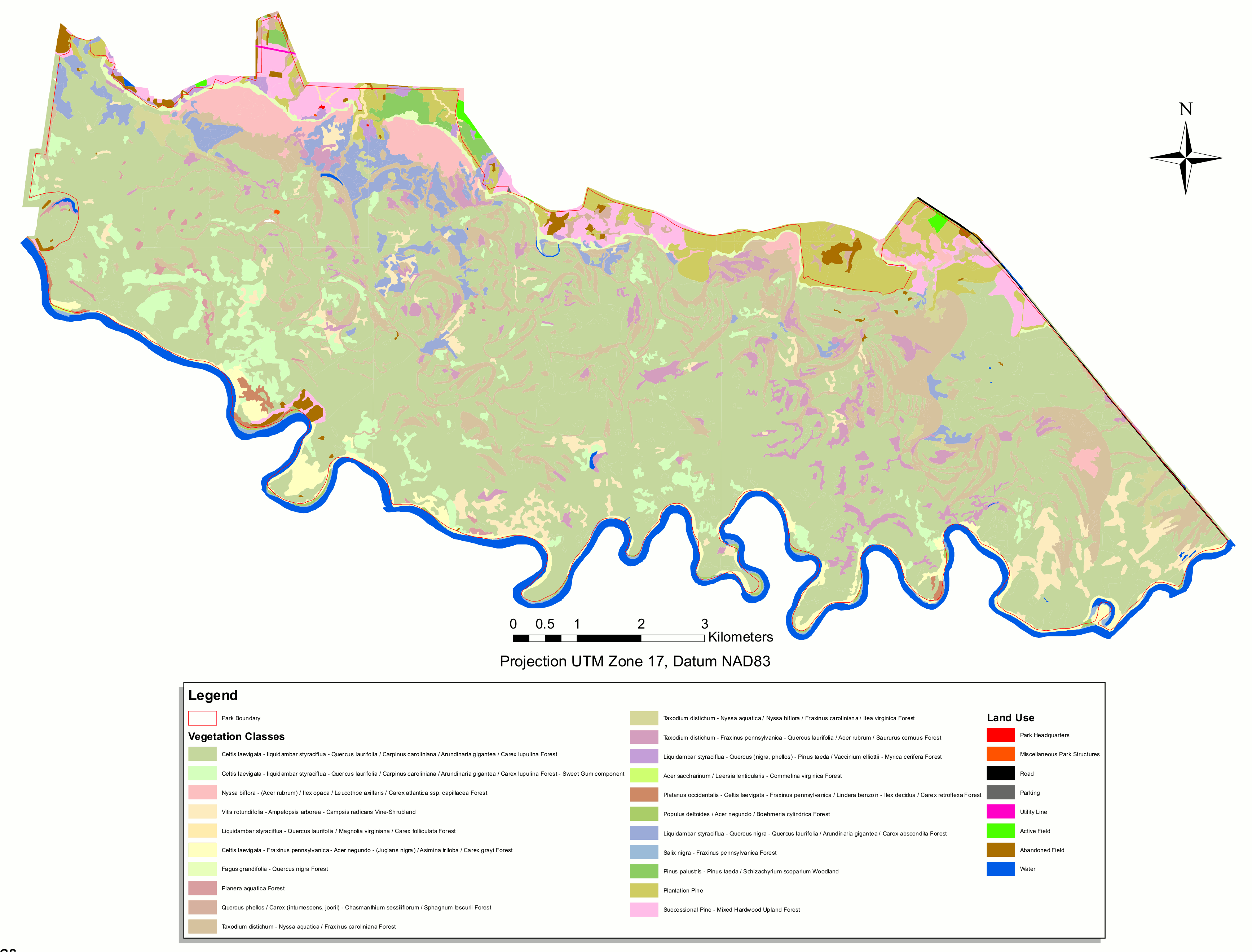
- Atlas Obscura (2025, May 12) How One Biologist Drew a Hyper-Accurate, Ranger-Approved Map of Congaree National Park. Accessed August 27, 2026.
- Discover South Carolina, Champion Trees are Star Attraction at Congaree National Park. Accessed August 27, 2026.
- National Parks Conservation Association (2024, March 27) Congaree: ‘Champion’ Trees, Synchronous Fireflies and More. Accessed August 27, 2026.
- National Parks Conservation Association (2017) The Wild Congaree. Accessed August 27, 2026.
- National Park Maps, Congaree Forest Map. Accessed August 27, 2026.
- National Park Service, Last Stand for Floodplain Forests. Accessed August 27, 2026.
- National Park Service, Congaree National Park. Accessed August 27, 2026.
- National Park Service (2014) Congaree National Park: Geologic Resources Inventory Report. Accessed August 27, 2026.
- U.S. Environmental Protection Agency, Bottomland Hardwoods. Accessed August 27, 2026.
- U.S. Geological Survey Ecology of Congaree National Park. Accessed August 27, 2026.
You may also be interested in:
Stay up-to-date with the latest content from NASA as we explore the universe and discover more about our home planet.

Sites relevant to the start of the American Revolutionary War are interspersed throughout the modern-day Boston metropolitan region.

The colonial communities of “America’s historic triangle” played defining roles in the road to American independence.

Along the northeast side of the Capital Beltway in Maryland, green spaces weave through the developed landscape.